Magnetic Iron Ore Exploration 

Petroseis has conducted numerous magnetic iron ore exploration surveys, which has led to sucessful mining operations. The survey was carried out using land magnetomter to map the iron ore deposit. Magnetic survey results are presented as planview chart which indicates the geographical distribution of the potential ore bodies. Optionally, this is followed by geoelectric survey and borehole investigation. An geoelectrical (IP and Resistivity) survey can be carried out to produce a cross section detailing the ore body along selected line, where estimation of depth to ore bodies and thickness of overburden is possible. Borehole sampling is normally conducted to verify the depth to the ore body and to quantify the iron content.

All the above information is valuable for mine operation planning.

Field Procedure and Data Processing

We collect magnetic total field data using land magnetometer within the designated area. Data collected were essentially processed for diurnal and heading corrections, before other processing procedures to bring out the best information from the data, which will enable confident interpretation of iron ore deposits. Magnetic total field data was provened to be an effective tool for iron ore deposit mapping. The same magnetometer is also good for underground structure detection. The figure below shows the typical magnetic total field map for a iron ore exploration conducted in a hilly forest in Malaysia.

Magnetic Total Field Display   Magnetic Analytical Signal Display

                     Total Magnetic Field Display  Analytic Signal Display


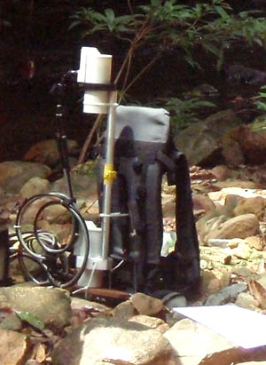
Photograph shows typical setup of a GSM-19G magnetometer for survey.

Magnetometer can be used for mapping geological structures, mineral exploration, and search for industrial, or archaeological features under the earth surface. The optional gradiometer attachment gives greater resolution and noise immunity for conducting searches in industrial or high cultural noise environments. It is also used has a base station for monitoring solar diurnal activities.

We use a Geometrics G856-AX proton precession magnetometer as base station to record the Earth's diurnal magnetic field. The field data acquisition is carried out using a more sensitive GSM-19G Overhausser magnetometer.

This Overhausser magnetometer is ideal for iron ore mapping. It allows accurate measurement with virtually no dependence of upon sensor orientation, temperature or location. The sensors can be mounted onto a backpack lightweight frame to allow the field technician freely move up and down the hilly terrain without any problem. Data is recorded into a console carried in front of the technician.

Land Magnetic Survey

Base Station


Contact us       Tel: +603 51319899    Fax: +603 51319855    Email: info2022@petroseis.asia    

PETROSEIS © ALL RIGHTS RESERVED

Home 

Geophysical Survey

Bathymetry Survey

Industrial Training 

HSE

Contact Us